Image audit
Every supplied photograph was screened in six contact sheets. The audit retains camera-area suggestions without turning them into building identifications.
| Image | Screening / subject | Area suggestion | Observation and limit |
|---|
DATE AND ORDER ANSWER DIFFERENT QUESTIONS
Several chronologies, kept distinct
A historical event is not a date for every wall. An interval can be a source range, a proposed reading or a display convention.
Accessible event list and exact bounds
SOURCE FIDELITY INCLUDES IRREGULARITIES
Bir Massouda’s published phase scheme
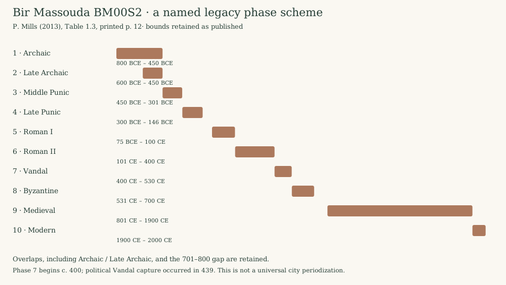
Mills’s initial BM00S2 scheme, Table 1.3 (2013), is a named archaeological grouping. The Archaic bands overlap; the “Vandal” phase begins around 400, before the capture of 439; a later gap remains visible. These are retained for inspection.
CONTACTS, SUCCESSION AND MEASURED HEIGHT
Read the vertical history carefully
The phase graphs below organize published statements. Their nodes are phase groups, not excavated context IDs; vertical spacing does not measure duration or depth.
Solid arrows: a published physical relationship. Dashed arrows: historical succession or redevelopment. Equal box spacing is an ordinal layout. Missing connections mean no relation is asserted here.
A HISTORICAL RECORD WITH A LOCAL DATUM
Room 18, Antonine Baths
Lézine’s record provides heights for ash, clay and earth above the room’s floor. This supports a scaled column for those deposits. The +1.06 m charcoal horizon has unspecified thickness; the upper fill has no recorded upper extent.
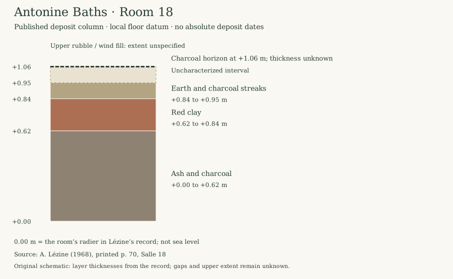
This room’s datum is not sea level. The column is a published historical record, with no modern survey confirmation, imported context IDs or absolute deposit dates. It cannot be transferred to another room or site.
EVIDENCE, MODELS AND THEIR LIMITS
What the images and records can support
Read plans as evidence
Compare a model drawn from published dimensions with a selective room diagram. Inspect the source conventions and the limits of each rendering.
Open the interactive plan reader →Published 3D resource: an unresolved identity
The Open Heritage 3D record’s title says “Amphitheatre”; its description says “Theater” and mentions modern festivals. It lists terrestrial LiDAR collected in 2012, published in 2020, CC BY-NC-SA, without georeferencing. Its viewer did not load during this audit. No dataset has been silently attached to either monument.
Inspect the dataset record ↗Resolve monument identity, the precise license terms, coordinates and viewer operation before incorporating a model.